Sunday, October 31, 2010
At Daytona Beach
Just before sunrise at Pine Island, FL we enjoyed the noise of the marsh for the last time on this trip. What you hear are rails, small birds that live in the
marsh grass, rarely fly and are almost never seen – they are about the size of mice. It was another perfect day with temperatures in the high 50’s to start and low humidity
It would be in the upper 70’s by the time we stopped about 3 pm. Today’s trip took us thru St. Augustine and then down to Daytona Beach. We did see quite a lot of local boat traffic
on the weekend, but only passed two sailboats. Near Palm Coast, FL we saw an eagle and about 15 miles north of Daytona we saw our first manatee in the water. We had not
yet seen a manatee zone sign and wanted to tell him to head back south!!! Tonight we anchored right in Daytona Beach. There is one sailboat with us but otherwise the waterway is quiet.
Today stats: Location Daytona Beach, Fl ICW MM 829.2, distance traveled 64.51 miles, average speed 8.43 mph ( 7.33 knots )
Saturday, October 30, 2010
Heading South after a Lay Day
We decided to wait out the cold front passage on Friday in Fernandina Beach, FL. When we walked into town on Friday morning it was filled with children trick or treating in costume
downtown at the local stores – very neat!! Then we walked about 3 miles down route A1A to the Radio Shack ( for a clock battery ),
Walmart ( for a few groceries ) and then to McDonalds for lunch. Today Saturday started with no wind, clear sky and temperature in the low 60’s. Just after leaving the marina over 20 small boats passed us heading to fishing grounds. During the day we mostly favorable currents but we started the trip near low tide and had to watch some shallow spots. Five or six large powerboats passed us but we did not pass any other boats ahead of us. We are anchored for the afternoon and evening just north of St Augustine, Florida. This part of the ICW has just a few decent anchorages and this is one of them. We have some weekenders with us fishing and just enjoying a great day on the water. Temperatures are in the high 70’s. At this point we think we will reach our condo in Stuart, Florida on Wednesday afternoon, but of course that depends on the weather
Today stats: Location-Pine Island, FL ICW MM 765, Distance traveled 48.45 miles, average speed 8.56 mph (7.46 knots).
Thursday, October 28, 2010
Crossed into Florida Today
It again was a summer-like morning with temperatures in the mid 70’s at sunrise and some clouds. Winds were light as we made our way
past Brunswick, GA and toward Jekyll Island. This is one of the trouble spots on the ICW with only 3.5 feet of water in spots at low tide.
We followed a sailboat in and had one spot with only 4.5 feet of water when our boat needs 4 feet. After that we made our way to St Andrews Sound where the ICW
touches the ocean. On our last trip we had a very rough time here so I decided to double check the winds by calling a automated wind buoy reading. The winds
were about 7 knots when we started the crossing but shifted to the west to oppose the incoming tide and even with just 7 knots it was a little lumpy when we made the turn
just short of the breaker line. The rest of the trip to Fernandina Beach, FL was calm. We filled up the boat with diesel at $2.85 per gallon and made our way to our slip
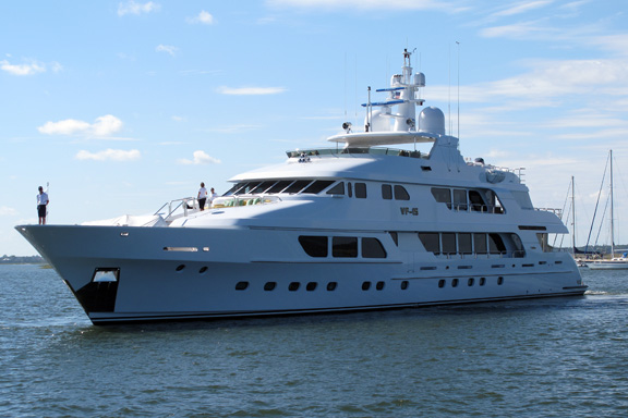
at the marine just in front of the old town. Just after we docked on the inside of the marina a 160 foot yacht called VF15 docked across from us. It is owned by the founder of
Enterprise Rent-a-Car. Mr. Jack Taylor, who flew as a naval aviator with Navy Fighter Squadron ("VF") 15 in WWII ergo "VF-15." The yacht has a crew of 10 and spends the winter
between the SE US and the Caribbean and the summer in the Med.
VF15:
Today stats: Location- Fernandina Harbor Marina, FL, ICW MM 716.5, distance traveled 47.08 miles, average speed 8.09 mph (7.03 knots)
Wednesday, October 27, 2010
Last Evening in the Magic Marshes
Last night at our Big Tom Creek anchorage the wind really blew. I estimate may some 20 knot gusts. With 8 feet of tide as it dropped we had more protection from the
marsh grass and that helped. The morning was a little foggy and very warm in the upper 70’s and little wind. That made for near-perfect conditions to cross
St, Catherine's, Sapello, Doboy and Altamaha sounds with nothing more than a light chop to deal with. We passed a group of 4 sailboats early in the trip and a couple of
powerboats passed us about mid-morning. The way the ICW twists in Georgia you often see another boat that looks like it is floating on nothing but grass.
This will be the last evening before we cross into Florida where the character of the ICW completely changes.
Tonight we are anchored with one other trawler near Ft. Frederica National Monument. In the 1742 battles of Bloody Marsh and Gully Hole Creek, forces under
Oglethorpe successfully repulsed Spanish attempts to retake St. Simons Island. Afterward the Spanish no longer threatened the colony.
Today stats: Location ICW MM 665.7 Ft Frederica, Frederica River, GA. Distance traveled 56.81 miles, speed 8.74 mph (7.6 knots)
Tuesday, October 26, 2010
Crossed into Georgia Today
We ducked a bullet last night. A really nasty line of thunderstorms passed between 6 and 8 pm. The worst was both north and south of us
and when we did get rain there was very little wind with it. It did get very humid and we decided to crank up the generator and turn on the A/C
to make the boat more comfortable – the “no seeums” are bad in the marsh and we had to keep the doors closed. Today we were part of a group
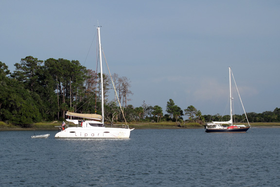
of 3 trawlers making our way into Georgia. We had high tide which helped with the skinny areas on this stretch. Tonight we are anchored in Big Tom Creek, GA
south of Savannah. A large sailing catamaran is anchored nearby and there is nothing but marsh for miles around. I have just enough signal for an
internet connection so I can post this entry.
Boats at anchor the night before in Bull Creek:
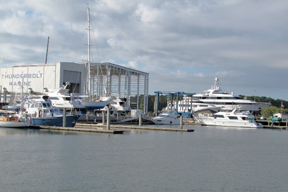
Check out the size of the new boat shed at Thunderbolt, Georgia:
Today stats: Location Big Tom Creek, SC ICW MM 612.8 Distance traveled 49.02 miles, average speed 8.53 mph ( 7.41 knots )
Monday, October 25, 2010
Change in Plans (AGAIN!!!)
The big blow forecast a couple of days ago is delayed until a cold front passed thru Thursday to Friday. We awake in Beauport, SC to calm winds and so once again decide
to move on down the ICW.
We are now in a section where anchorages have minimal wind protection so instead of running a full day we did a short leg to a better anchorage.
Unlike previous days, today we were in a train of 7 trawlers going down past the Marine Base at Paris Island and across Port Royall Sound. We only passed one sailboat.
Winds stayed light, but current was against us. Today also was our first cloudy day of the trip, but a warm one starting out in the high 60’s and going
to the low 80’s. Winds picked up into the mid-teens after we anchored and we are watching closely a line of thunderstorms to our west. Tomorrow we will cross into Georgia.
We are now in the section of the ICW with no dredging or maintenance for about 10 years. There are two other sailboats with us in the anchorage from which we can see
the Harbor Town Light at Hilton Head, SC.
Today Stats: Location Bull Creek, SC ICW MM 565 distance traveled 29.70 miles, average speed 7.98mph (6.94 knots)
Sunday, October 24, 2010
Change in Plans
You have to be flexible if you want to cruise on a trawler. I got up this morning, checked the weather on the computer and saw
that the wind forecast for Monday had increased to 15-20 knots from the south. I then made a quick decision I would rather be further south so I had to wake Sandra up
to tell her to get the boat ready to leave on 30 minutes notice. We headed south in calm conditions and clear weather. For most of the day we had a falling tide and favorable current
and made great time for a trawler. As the day progressed we had some could and winds did fill in from the south but not as much as predicted.
Our destination was Beaufort, SC. We had not stopped here in 5 years because the downtown waterfront was being rebuilt.
The town has done a wonderful job and we enjoyed a nice brick oven pizza at a local restaurant. I plan to continue to monitor the weather and if winds stay down we
will make our way to the Savannah area tomorrow.
Today Stats: Location Downtown Marina, Beaufort, SC ICW MM 536, distance traveled 65.90 miles, average speed 8.88 mph (7.72 knots)
Saturday, October 23, 2010
Perfect Weather in Charleston
Another picture perfect day. It started out in the mid 50’s and by mid-day it was in the low 80’s with low humidity which is rare in Charleston.
We timed our short run to get into the City Marina on slack tide, tied up the boat, cleaned it and then headed into town for shopping. One part was fun -
Sandra looking for clothes and candy; the other part was to restock boat. After this stop we normally only use marinas if we need to due to weather
so we want the boat ready to go for the rest of the trip. We will spend another day here ( our favorite city on the east coast of the US ) and then resume south on Monday
morning.
Here is a picture last night in our anchorage on Dewees Creek, SC as the moon came up:
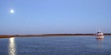
Today Stats: Location City Marina, Charleston, SC ICW MM 469.3, distance traveled 15.57 miles, average speed 7.41 mph (6.44 knots)
Friday, October 22, 2010
I guess I will have to keep knocking on the teak handrails of the boat – the weather again is perfect for boating. We left the quiet anchorage off the Waccamaw River and made our way back to the coast
past Georgetown, SC. Once again the tide and current was favorable almost all of the time. I know know that you will get a good ride toward Charleston if the tide is going out and the reverse is true northbound. Winds started very light today but picked up to 10 knots or so from the NE. We did not see anything more than a light chop on the water. The highlight of the day was seeing an eagle along
the shore of the Esterville-Mimm canal near ICW MM 413. Traffic was again light in the ICW, we passed 2 sailboats and two sport fishing boats passed us as well as one large barge going in the opposite direction. Tonight we are anchored in Dewees Creek just short of Charleston. This will give us a short 2 hour run tomorrow and allow us to enjoy the day in town. Anchoring is always interesting with 6 feet of tide change and the current. I had to turn the boat around in the creek to anchor so I would be facing into the wind and current and that was fun in the narrow creek with both the NE wind and the current trying to push the boat back.
Today stats: Location Dewees Creek, SC ICW MM 454.9, Distance Traveled 66.81 miles, average speed 8.76 mph ( 7.61 knots )
Thursday, October 21, 2010
We again started with a calm morning in the mid 50’s. For the first 21 miles we were in what amounts to a straight canal through Myrtle Beach. To me the development along these
banks represents some of the worst of the excess of the past real estate bubble. House after house and condo after condo, many empty. Then suddenly you are in one of the great rivers on the east coast, the Waccamaw that winds thru swamps with no development to be seen. We made a quick stop for fuel in the first part of the Waccamaw and paid 2.69 per gallon – I estimated I burned about 2.64 gallons per hour since I last filled up. In general fuel gets more expensive the further south you travel. Tonight we are anchored off the ICW in a quiet creek. We had favorable current today and at high tide the banks were full of large snapping turtles sunning themselves. Boat traffic was again light, we passed a few sailboats and saw one other trawler. Below is a picture of Harry the Heron near Myrtle Beach, SC.
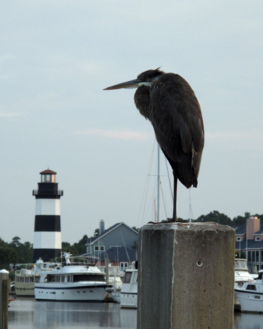
Today Stats: Location Thoroughfare Creek, SC ICW MM 388.9, distance traveled 42.12 miles, average speed 7.92 mph ( 6.89 knots )
Wednesday, October 20, 2010
This morning was another near perfect day to travel by boat. Temperatures in the low 60’s at sunrise and light winds. We had a favorable current down the Cape Fear River and then turned back into the more confined waters of the ICW to make our way toward Myrtle Beach, SC. The challenge on this stretch is the Sunset beach Cable Pontoon bridge that only opens on the hour. A new high rise bridge was supposed to be open by now, but the hot summer weather delayed construction. About 2 hours before we reached the bridge I realized from the GPS that we could not speed up enough to make the 12 noon opening so we had to slow to a crawl ( 6 mph ) because we would arrive at low tide and waiting in front of the bridge can be dicey. Only two other boats passed thru with us and when we return in the spring it will be gone – the end of an era. Tonight we are staying at a dock owned by a fellow Marine Trawler Association member near North Myrtle Beach, SC.
Today Stats: Location Coquina YC, Little River, SC ICW MM345.9 Distance Traveled 52.64 miles, average speed 7.36 mph ( 6.40 knots )
Tuesday, October 19, 2010
We had a very windy night at the anchorage in Camp LeJeune, NC. Just before sunset a sailboat anchored almost on top of use with plenty of other space available – go figure? In total there were 10 boats in the anchorage over night.
Today’s run down the coast of NC is pretty, but has three restricted bridges. I set my GPS for the first one and made it exactly on time. Only two other trawlers also made that opening; all the sailboats in our anchorage misjudged the current and did not make it. Once past the Surf City Bridge we headed for the Figure 8 Bridge about 2 hours away. The good news is that I hit the bridge at near low tide and the extra 3 to 4 feet allowed me not to open the bridge or worry about timing. The same thing happened at Wrightsville Beach and we cruised into the dock at federal Point YC at Carolina Beach, NC just after 1 pm – what a great day!
Today Stats: Location Carolina Beach, NC ICW MM 296, distance traveled 51.61 miles, average speed 8.10 mph, 7.04 knots
Monday, October 18, 2010
There are almost no tides on the ICW between Norfolk & Oriental, NC. Today we returned to 3 1/2 foot tides as we approached Morehead City, NC. The tides can generate favorable current and sometimes it can slow my boat as much as 2 knots. Today we had both but the good current outnumbered the bad. When we left the anchorage there were 4 sailboats with us. So far on the trip we have not seen another trawler until today near Swansboro, NC We also saw our first dolphins on this trip just after we left this morning.. After Morehead City the ICW turns west and slowly curves down the coast toward Cape Fear. We had one restricted bridge today an Onslow Beach and Camp LeJeune. I head the bridge tender over the radio tell a sailboat he had to be there “exactly” on the hour to get the opening. We lucked out, we were about 5 minutes late with a bad current against us, but a tug was ahead of us and the bridge tender held the opening for both of us. Tonight we are anchored in the Mile Hammock Basin which is a part of Camp LeJeune.
Today Stats: Location Mile Hammock Bay, Camp LeJeune, NC ICW MM 244.5 Distance traveled 58.72 miles, average speed 8.38 mph, 7.29 knots
Sunday, October 17, 2010
Winds were almost calm when we left Washington, NC at sunrise with temperatures in the high 40’s. Saturday evening at the suggestion of locals we joined a Ghost Walk through town and had a great time. Today’s run took us 30 miles down the Pamlico River then through a short canal to the Neuse River. In reality you are coming down Pamlico Sound in open water and the Neuse itself is about 5.4 miles wide at its mouth and 4.25 miles wide where you reenter the protected part of the Intracoastal Waterway. Even with only 5-7 knots of wind we saw 1 to 1.5 foot waves on this river which is less than 20 feet deep. Tonight we are anchored just below the Neuse and will have protected waters almost all of the way to Charleston, Sc which we hope to make by next weekend.
Sunset on Cedar Creek, NC
Today’s Stats: Location Cedar Creek, NC ICW MM 187.5 distance traveled 66.58 miles average speed 8.88 mph ( 7.72 knots)
Friday, October 15, 2010
OK, I admit it – it was not a shorts day today – started in the 40’s and with a brisk wind it was time to break out the jeans for
for the first time on the trip. I went to turn on the heat in the main salon and discovered the control that gives heat on our
forward AC/Heat Pump unit was loose –a few tie warps and we had heat again. For the techno: the reversing valve solenoid was loose.
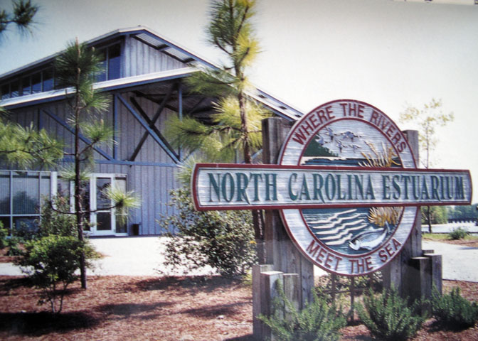
We visited the North Carolina Estuarium and had a great time – the intro movie and all the exhibits were great – I recommend it if you are in the area.
The lobby has a wonderful interactive sculpture that depicts the water cycle between the land sea and air.
Thursday, October 14, 2010
We left Bond Creek after sunrise in light fog and haze and no wind. There is a shortcut between Indian Island & Long Point and I was not sure I could make it across, but it was calm and waters are above normal from all the recent rain so we gave it a try and no issues, had no less than 6.8 feet of water – that saved us 4 miles going up the Pamlico to Washington, NC, The rest of the run was quiet on flat water but poor visibility and I was happy to have the chart plotter to guide me. We arrived at the Washington City docks at about 10:40 am just before a line of rain and thunderstorms passed thru. We escaped the worst of the weather and by mid-afternoon it had already cleared. We plan to spend two days in Little Washington before resuming the trip south. You can view our boat on the local web cam – we are on the middle dock to the left of the T-head here:
http://www.witn.com/cams/misc/7581727.html
Today’s Stats: Location- Dock, Washington City Docks, NC MM 150+33 miles upriver Distance traveled 28.43 miles, average speed 8.36 mph (7.27 knots)
Wednesday, October 13, 2010
Weather forecasts are always interesting – it was supposed to be winds NE 10-15 knots today, yet when we left Alligator River marina it was almost calm. A couple of hours after sunrise the winds did fill in, but at times during the day they were light and whatever chop we had on the water was usually on our stern. The predicted cool-down did not happen, it was 79 degrees today in eastern North Carolina. The only real bumpy part to the trip was the last 4 miles when we turned into South Creek off the south shore of the Pamlico River to reach the dock of my friend and fellow trawler owners Phil & Avan Rosch. We are their guests tonight. Tomorrow we will head up the Pamlico River to visit the town of Washington, NC
Today’s Stats: Location- Dock, Bond Creek, NC MM 150 Distance traveled 72.24miles, average speed 9.03mph (7.85 knots)
Tuesday, October 12, 2010
We started from Norfolk and faced the rush hour restrictions on the bridges – the first bridge would only open at 8:30 am. There were 7 other boats with us at the first bridge. By 11 am we passed the last bridge and had gone 20 miles. It was a beautiful day in the low 80;s and as we made our way further south we decided to keep going because tomorrow was forecast to be rougher on Albemarle Sound. It was just before sunset at 6:15 pm when we reached Alligator River Marina at Mile Marker 84 of the ICW. After a quick fuel stop we settled in for the night knowing that the “big water” is now behind us.
Today’s Stats: Location- Alligator River Marina, NC MM 84 Distance traveled 85.17 miles, average speed 7.74 mph
Monday, October 11, 2010
Sometimes the weather gods smile – today was one of them – we left our home at sunrise and made our way down the bay in shorts weather.
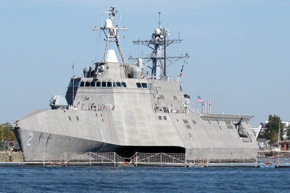
There was little chop around Mobjack Bay and the York River and then it settled down as we approached Hampton Roads. We had some interesting traffic near the Naval Base, the picture below is a new class of British navy destroyers and this is the HMS Daring. It was just heading to sea as we passed. The second vessel was at the docks and is a Littoral Support vessel; it is a trimaran and goes 50 knots used to support special ops and similar missions.
Tonight we are anchored off Hospital Point in Portsmouth, VA and will face the restricted bridges tomorrow heading to NC.

Today’s stats: Distance traveled 63.39 NM ( 72.9 miles ), average speed 7.46 knots ( 8.58 mph ) current location, Portsmouth, VA ICW MM 0
Friday, October 08, 2010
We are just about ready to head south on Monday morning. The weather is looking good and Sandra has almost everything for the galley on
the boat. I just finished washing the interior and exterior and checking the chartplotters and GPS equipment. Now I need to put the cars and truck to bed
for the winter and finish closing up the house.
Friday, October 01, 2010
What a storm !!!! From Wednesday evening to Friday morning we had 12 inches of rain in my gauge. I am sure that broke every record . We did not have any excessive wind and tides are about 2 1/2 feet above normal right now.
![]()