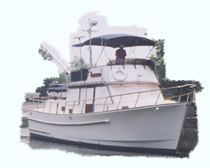
Tuesday, October 31, 2006
Georgia Sea Islands
The day again started perfect for boating: 50 degrees, clear and no wind. It warmed up to almost 80 degrees. Just like yesterday we saw very few boats on the waterway; we passed 2 sailboats and no power boats passed us. From the radio chatter I think many boats are offshore in the fine conditions. Seas off shore are 2-3 feet and you can save 30 or 40 miles of travel by going out near Savannah and going back in at Jacksonville, Florida. The ICW in this area meanders from river to river and often turns back on itself. We did one section at low tide and saw as little as 5.5 feet of water; out boat needs 4 feet. This section in Georgia as had no dredging in maybe 5 years and it shows. There is no commercial traffic here so the Federal government will not fund the dredging and the state of Georgia has not shown an interest in helping out either.
Tonight we are anchored in Big Tom Creek below Savannah. To the north we can see the city lights glow and all around are the marshes. As far as we can tell we are the only boat in the area.
Today's Stats: Location Big Tom Creek, SC ICW MM 613, time travelled 5.87 hrs, average speed 8.45 mph
Tonight we are anchored in Big Tom Creek below Savannah. To the north we can see the city lights glow and all around are the marshes. As far as we can tell we are the only boat in the area.
Today's Stats: Location Big Tom Creek, SC ICW MM 613, time travelled 5.87 hrs, average speed 8.45 mph
Monday, October 30, 2006
Fine Day In South Carolina
The morning was foggy and we delayed starting about 30 minutes to let it burn off. Once underway we quickly passed a sailboat and then except for a few more sailboats we did not pass or get passed by any other boats. It was clear and temperatures quickly warmed to the upper 60's with near calm winds. Today's run passed thru Beaufort, SC than the Marine Corp Base at Parris Island; across Port Royall Sound and Hilton Head. Tonight we are anchored in Bull Creek and can see Harbor Town in Hilton head from the boat. There are just a few houses on the shore and one dock. We will leave South Carolina tomorrow and begin the 3 day trip across the sounds of Georgia.
Today's Stats: Location Bull Creek, SC ICW MM 565.5, time travelled 6.25 hrs, distance 54.59 miles, average speed 8.73 mph
Today's Stats: Location Bull Creek, SC ICW MM 565.5, time travelled 6.25 hrs, distance 54.59 miles, average speed 8.73 mph
Sunday, October 29, 2006
A Delight in the Island Country of SC
We left the Charleston City Marina on slack tide at about 6:30 am helped by the change to Standard Time. The large fast boats left ahead of us so I did not have to deal with them passing me. The days trip down the rivers of SC in what they call Island Country was as nice as a day on the ICW can be. The development, when there is any is set back and usually hidden by trees. We passed a few sailboats and towards the end of the run a few faster powerboats passed us. Tonight we are anchored in the Ashpoo River a few miles off the ICW. There is just one house nearby and we have see only one small boat since stopping here. Friends of ours who also cruise, Bob McLeran and Judy Young on Sanderling, recommended this place to stop.
Today's Stats: Location Ashepoo River, SC, ICW MM 513.5, time travelled 5.5 hours, distance 46.85 miles, average speed 8.52 mph .
Today's Stats: Location Ashepoo River, SC, ICW MM 513.5, time travelled 5.5 hours, distance 46.85 miles, average speed 8.52 mph .
Saturday, October 28, 2006
Good Day in Charleston
The winds did blow Friday afternoon and evening in Charleston. The nearby Coast guard station clocked over 40 mph. I spoke to a passenger on a cruise ship returning from Bermuda yesterday; they had 75 mph winds and 20 foot seas!!! The boats on the outside of the dock banged load enough to keep us up some of the night. This morning found clear skies, winds 15-20 from the NW and 60 degree temperatures. We dried the boat, has a nice breakfast at a nearby restaurant and then went into town.
MegaDock at Charleston
MegaDock at Charleston
Friday, October 27, 2006
Rain on the way to Charleston
As predicted the rain started before sunrise on Friday. We pulled up anchor in the dark wanting to get to Charleston as soon as possible to avoid the coming fronts and winds. The tide was favorable, winds very light and we pulled into the City Marina at 11:33 am. We are on the inside of the MegaYacht Dock and hope it will provide enough protection if the winds pick-up. After we arrived we purchased 173 gallons of diesel fuel. Fuel consumption for this leg of the trip averaged 2.79 gph or about 2.94 mpg. The prices are a little higher now ( $2.249 ) which I think is a result of the early cold in the Northeast. Diesel fuel normally tracks #2 heating fuel prices in the winter months. Just up from us on the the dock are MTOA members Jim & Cathy Fisher aboard @HOME. We plan to stay here 2 nights, catch up on the mail which we picked-up and enjoy the sights. The weather should clear tomorrow.
Today's Stats: Location Charleston City Marina, SC ICW MM 469.3, time traveled 4.7 hours, distance 40.1 miles, average speed 8.53 mph
Today's Stats: Location Charleston City Marina, SC ICW MM 469.3, time traveled 4.7 hours, distance 40.1 miles, average speed 8.53 mph
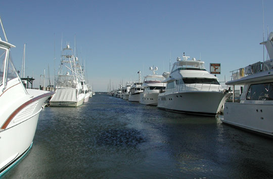
Thursday, October 26, 2006
Magic on the SC Low Country
I could not make up my mind how to to handle the coming fronts and their winds due to hit here Friday afternoon thru Saturday morning. We decided to compress what is normally a 3 day run from Myrtle Beach to Charleston into 2 days. Today we did the run thru the Rockpile where you have to go slow to avoid rocks on both sides of the channel. This extends about 10 miles thru Myrtle Beach. After that we had a great run down down the unspoiled Waccamaw River and then past Georgetown, SC to the marshes of the Cape Roman National Seashore. The warmer weather ( started 45 degrees , got to middle 60's, light winds ) allowed us to steer from outside and made everything better and more pleasant. Tonight we are anchored near McClellanville, SC in Five Fathom Creek with 3 sailboats. To our east all you can see is 5 miles of marsh grass to the ocean. Tomorrow we will depart early to make Charleston we hope before the winds and real rain arrives.
Today's Stats: Location Five Fathom Creek, SC ICW MM 430, time travelled 9.5 hrs, distance 82.93 miles, average speed 8.73 mph
Boats on the Waccamaw River, SC

Today's Stats: Location Five Fathom Creek, SC ICW MM 430, time travelled 9.5 hrs, distance 82.93 miles, average speed 8.73 mph
Boats on the Waccamaw River, SC
Wednesday, October 25, 2006
On to Myrtle Beach
Cold, yes it was cold. 35 degrees in the morning setting a record for a low in these parts. We left at sunup and headed down the Cape Fear River. This has been rough for us at times, but today there was just a little swell from the incoming tide. That was the problem, we had about 2 knots of current against us. We also had to deal with about 10 large high speed motoryachts and Sport Fish, some using the inside shortcut from Wrightsville Beach to Southport before going offshore again. One boat "April Fool" a 60 ish foot sport fish really waked us; never called on the radio and never slowed down. After that we had a good trip toward North Myrtle Beach. The slow river run resulted in us being about 20 minutes late for a bridge that only opens on the hour. Using the GPS I slowed down to 7 mph and used up the extra 30 or so minutes and only had to wait about 5 minutes at the bridge. Just after that near Myrtle Beach the current shifted against us and slowed us down again to less than 7 mph.
Tonight we are at Dock Holidays Marina in North Myrtle Beach. We have stayed here before because you can walk to the Food Lion, West marine, CVS, Advance Auto and restaurants. Once again we are looking at unsettled weather as the next front arrives around Friday & Saturday. We may hole up at a good anchorage down a little ways, but I will make another weather check before final decisions. The decision is more difficult because in about 50 miles we lose anchorages with trees and go into the marshes of the South Carolina low country.
Today's Stats: Location - North Myrtle Beach SC, ICW MM 348.2, distance traveled 56.15 miles, time 7.5 hours, average speed 7.49 mph
Tuesday, October 24, 2006
Windy, Cold & 3 Bridges to Make!!!!
Sunrise at Camp Lejeune was cold and windy ( 39 degrees and 15 mph winds ). We pulled up anchor at sunrise to make on schedule the first of three restricted bridges on this section of the North Carolina Beach country. Two of the bridges only open on the hour, one every half hour. The GPS lets you pace the distance, but you have to watch the currents here. With many inlets you can quickly go from 10 mph to 6 mph at the same engine rpm. Today everything worked out, the first bridge was at a normal pace, the second at a slower pace ( 7 mph ) and the third bridge at Wrightsville Beach at a fast pace since it was five miles away in 30 minutes time ( 10 mph ). A group of three power boats made the dash to that bridge. The boat behind me called Go Fourth was about 80 feet long, but the captain realized I was on pace to make the bridge and did not try to pass me which would have slowed my progress. I thanked him on the VHF radio for that courtesy.
Tonight we are at a small private marina in Carolina Beach, NC that rents a few slips overnight. We had time to wash all the salt off the boat and do some laundry.
Today's Stats: Location Carolina Beach, NC, ICW MM 295.1, distance traveled 51.86 miles, time 6.88 hours, average speed 7.54 mph
Sunset at Mile Hammock Bay, NC
Monday, October 23, 2006
Cool & Windy
This morning we got up and were undecided if to stay at the anchorage at Cedar Creek or go down the waterway through Morehead City. The wind forecast was 15-20 on the water and 10-15 on the land from the NW. Just before sunrise it did not seem so windy so we decided to go. It worked out OK. Except for a short piece of open water above Morehead with some waves the ride was good and once we made to turn at Morehead down bough Sound ( heading West!! ) we had a very nice incoming tide giving us near 10 knot speed over the ground. Just above Morehead City you transition from no tide to 3 1/2 feet of tide which generates the currents. Large tides and currents will be with us until we pass Northern Florida. Today just as last year we saw our first dolphins just above Morehead City. We had good luck with the one bridge we had to open arriving just in time for the opening on the half hour. This bridge at Onslow Beach is run by the Marine Cops and the bridge tender said I had to make it on time since he had some tanks scheduled to cross soon after.
At that bridge we were behind a 60 foot or so motoryacht with a delivery crew. The bridge opened and the captain of that boat instead of going through started to talk on the cell phone. Only after the tender yelled at him did he move - and that is a "professional" captain.
Tonight we are at the Marine Corps Basin at Mile Hammock Bay at Camp Lejeune, NC. Some years we have had intense exercises and live fire while we were here, but except for a few helicopters it seems quiet. Maybe the night will be different. We were surprised to find the anchorage empty when we arrived at about 1:40 PM. I had expected some to stay over to avoid the wind and cold. We will not have much traffic behind us know because for the next 3 days or so it will not be possible to cross the sounds in North Carolina.
Today's Stats: Location, Mile Hammock Bay, NC, ICW MM 244.5, time travelled 6.5 hours, distance 58.19 miles, average speed 8.95 mph
Sunday, October 22, 2006
Palmico & Neuse Behind Us
We were up in the dark so we could leave at first light. Our friends from Yankee Point Marina the Popes aboard Dream Catcher left just before us and Sandra said I only made us get up so early to try to be first out!!!! The morning was calm and we had near flat sea conditions down the Pungo River, across the Palmico River and then through a cut to the intersection of Palmico Sound and the Neuse River. At its mouth, the Neuse is as big as any Bay and can be rough under bad conditions. Today we had just an East wind of about 7 MPH and maybe a 1/2-1 foot swell off the sound. That is about as good a crossing as you will get for this body of water. We made our way down the Neuse in a long line of boats and tonight are anchored just off the Neuse in Cedar Creek. We were the second boat in, but there are now 5 boats and I expect more as it gets later. The next few days weather forecast is unsettled as well as cool and we may have to take a lay day if winds pick up as they forecast.
Today's Stats: Location Cedar Creek, NC ICW MM 187, distance traveled 58.9 miles, time 6.5 hours, average speed 9.06 mph
Today's Stats: Location Cedar Creek, NC ICW MM 187, distance traveled 58.9 miles, time 6.5 hours, average speed 9.06 mph
Saturday, October 21, 2006
Albermarle & Alligator Done
We left Coinjock Marina just before sunrise at 6:58 am. They pack they boats in bow to stern and we had just enough room to swing the bow out with the thruster and leave. That created enough space for the boat ahead of us to also leave. The boat in from of them was not even out of bed at 7 am. That is always an issue at this marina, will you be able to leave when you want to.
Winds this morning were less than predicted and by the time we reached Albermarle Sound they were maybe 10 knots from the North. We still had a 1-2 foot swell left over from the previous night, but given how nasty the crossing can be I rated it a 8 out of 10. The Alligator River also had a swell, maybe one foot, but no problem. There is no tide here so current is not an issue and we made a solid 8 knots all day.
Tonight we are anchored at the bottom of the 21.3 mile long Alligator- Pungo River Canal. We arrived first, but there are now 9 boats anchored and with two more coves available you could have maybe 30 boats here if necessary.
Today's Stats: Location Upper Pungo River, NC, ICW MM 127.5, distance travelled 78.84 miles, time 8 3/4 hours, average speed 9.01 mph
Boats at Pungo River Anchorage
Friday, October 20, 2006
Bump on a Lock Wall
The morning in Portsmouth brought rain, but when we left the anchorage about 8 am it was dry and would stay that way all day. This is a frustrating part of the trip with 5 bridges to open and one lock. The bridges have restrictions due to increasing traffic in the Norfolk area, but I always notice that some of them have little traffic when we pass. At the Steel bridge ( Dominion Blvd ) we had to wait in a tight area with other boats for over 30 minutes ( the bridge only opens on the hour ).
Temperatures warmed nicely and there was even sun a mid-day before the cold front arrived.
In the Great Bridge lock we went in without trouble, but while tieing up to the wall the stern of the boat started to swing and while I was handling the engines I hit the throttle which resulted in a bump and some scratches that will need repair. It bummed me out, not knowing how I hit the wrong lever.
After that we did the last two bridges, running 10 knots to make one of them. At another we have a tug pulling about a football length bundle of dredging pipe come through northbound leaving us just enough room to stand by on the side of the channel. The last 10 miles were through open Currituck Sound and winds were over 20 with some 2-3 foot waves.
Tonight we are at the marina in Coinjock, NC and were joined for dinner by David & Charmaine Pope who are members of YPYC Yacht Club with us.
Today's Stats: Location Coinjock Marina, NC, ICW MM 49.3, distance travelled 49.3 miles, average speed 6.8 mph.
Thursday, October 19, 2006
A Great Start to the trip!!!
We had the boat packed and ready to go Wednesday night with time to spare. Nice weather makes it much easier. Before daybreak we found thick fog around our house. We just before 7 AM and I used the GPS chart plotter to guide me thru the fog. I have it set to always point in the direction you are traveling and that helps in tough conditions. I also had the track saved from my last trip to Portsmouth, so I just followed the "bread crumbs." When we reached the Rapphannaock River turned the radar on to help identify any boats nearby. With the conditions we only saw a few crabbers and one head boat running empty inbound on the river. The fog lifted about 10 am, but it stayed cloudly until we reached Hampton Roads. There was only a light swell in the southern Bay and the autopilot steered the boat all the way down. Tonight we are anchored off Hospital Point in Portsmouth, which is Mile Marker 0 of the ICW. There are less boats than the last few years ( about 14 now at 5 Pm ). It could be we are a little early for the bulk of the crowd ( which is good ) or less people are making the trip?
The weather is supposed to be unsettled with a front tomorrow and I will have to decide to anchor or go to a marina tomorrow in NC.
Today's Stats: Location Hospital Point, Portsmouth, VA ICW MM 0
Distance traveled - 63.23 nm, average speed 7.52 knots ( 8.64 mph )
The weather is supposed to be unsettled with a front tomorrow and I will have to decide to anchor or go to a marina tomorrow in NC.
Today's Stats: Location Hospital Point, Portsmouth, VA ICW MM 0
Distance traveled - 63.23 nm, average speed 7.52 knots ( 8.64 mph )
Tuesday, October 17, 2006
Just about ready to Go
We are in the final details of getting the boat ready to head south. A slip will be available when we get to Stuart, FL which will be our destination. I loaded one bike on yesterday knowing it would rain today. We will get Sandra a bike when we arrive in Stuart next month. The weather is now looking good to go down the bay on Thursday, October 19. Looking further out it looks OK, but not great to cross Albermerle Sound in NC a couple of days later. I will soon also find out if adding a vent and fan has helped the running time and cooling of my refrigerator.
Thursday, October 05, 2006
I have spent the last two weeks getting the boat ready to go South again. We are still not 100% sure we are going, but I wanted to be ready and had the boat hauled last week. While out of the water I checked everything, painted the bottom, had the propellor checked and balanced, replaced all the zincs, waxed the hull etc. Punches is ready to go back in once I am sure we will have a slip in Florida for the winter. We should know in a few days.
Punches on the Hard at Yankee Point Marina, VA:

Prop after Cleaning:

Punches on the Hard at Yankee Point Marina, VA:
Prop after Cleaning:
![]()